NASA satellite images show how the land beneath major US cities such as Baltimore, New York and Charleston is sinking at an astonishing rate.
On February 20, images revealed by NASA’s Earth Observation Station show land movement along the East Coast, with dark blue areas in particular showing the fastest sinking. This sinking threatens infrastructure, farmland and wetlands – especially as sea levels rise.
Between 2007 and 2020, the ground beneath the cities of New York, Baltimore and Norfolk, Virginia, sank an average of 0.04 to 0.08 inches (1 to 2 millimeters) per year, according to satellite data showing that the rate doubled or tripled in several counties in Delaware, Maryland, South Carolina and Georgia. According to a study published January 2 in the journal PNAS Nexus.
“Sinking is a relatively localized and often overlooked problem compared to global sea level rise, but it is an important factor explaining why water levels are rising in many parts of the eastern US,” Leonard Ohenhen, a geophysicist from Virginia Tech and co-author of the study, told NASA’s Earth Observation Station.
Submergence has many consequences for people living on the coast, including increased risk of flooding and damage to homes and infrastructure due to unstable ground. According to the study, at least 867,000 properties and critical infrastructure – including highways, railways, airports, dams and levees – are all in danger of sinking.
Sinking can lead to salt water entering farmland, crops and freshwater sources; it can also affect habitats such as marshes, according to the NASA Earth Observation Station.
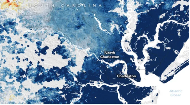
One of the fastest sinking cities is Charleston, South Carolina, where the central area is only 10 feet (3 meters) above sea level. The city sinks about 0.16 inches (4 mm) per year.

According to NASA’s Earth Observation Station, the sinking in Charleston is largely triggered by human activities such as groundwater withdrawal. When people drain underground water tables or extract natural gas from underground, the remaining voids can collapse and submerge the land above it. But in places like New York, a combination of factors, including soft ground as well as the weight of structures, contribute to the sinking process.
The researchers used satellite imagery and ground-based GPS sensors to study the coast from New England to Florida. They then created a map revealing the variability of the rise and fall of various regions along the coast. This data was compared with data collected by the ground-based Global Positioning Satellite System to determine the sinking rate.
According to the maps, the Mid-Atlantic region is sinking more than the northeastern US. This is largely due to glacial isostatic adjustment, a geological process that is the ongoing movement of land that was burdened by heavy ice sheets during the last ice age. The last ice age lasted from about 126,000 to 11,700 years ago.
The edge of the giant Laurentide ice sheet ran through what is now Pennsylvania and New Jersey, and the weight of the ice pushed the land downwards. Meanwhile, the land outside the ice was pushed upwards. As the ice melted about 12,000 years ago, the land that once swelled along the coast began to sink, and it is still continuing.
Manoochehr Shirzaei, co-author of the study and director of the Virginia Tech lab, said the researchers hope to map the coast of the Gulf of Mexico as the next step. “Our long-term goal is to map the entire coast of the world using this technique,” he said in a press release. “We know that planners in several US cities are using our data to make our coasts more resilient, and we want cities around the world to be able to do the same.”