Researchers utilized Earth-orbiting satellites to create a global map of coral reef biodiversity, revealing a strong correlation between areas of high habitat diversity and high species diversity. This groundbreaking satellite mapping technique, developed by the University of Miami Rosenstiel School of Marine, Atmospheric, and Earth Science research team, has the potential to inform future efforts aimed at identifying and safeguarding highly biodiverse reefs.
“As remote sensing technology advances and satellite imagery becomes increasingly integral to mapping ecological habitats, it’s crucial to grasp the biological and ecological significance of these data,” explained Sam Purkis, Professor and Chair of the Department of Marine Geosciences at the Rosenstiel School and senior author of the study. “Our research demonstrates that these maps can serve as a proxy for biodiversity, thereby guiding ecosystem protection and restoration initiatives.”
Conducting SCUBA-diver surveys to assess coral reef biodiversity is traditionally laborious and costly. Consequently, the research team sought a novel approach utilizing remote sensing to generate habitat maps on a global scale.

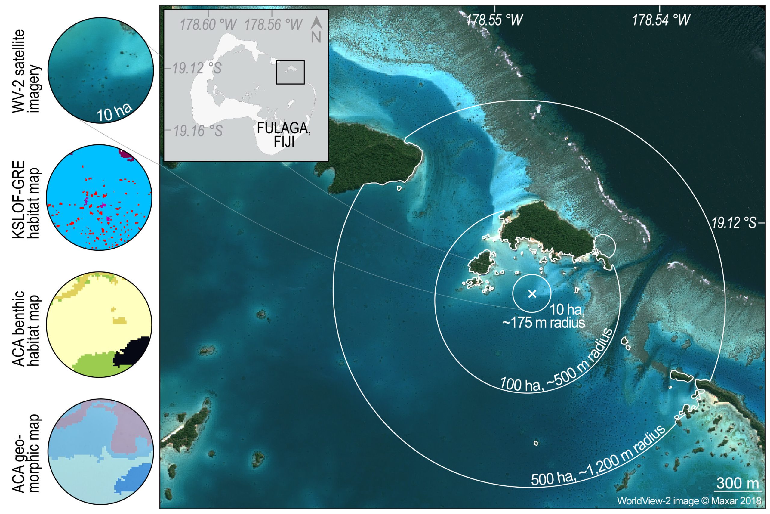
For their study, they analyzed data on reef fish and coral species diversity obtained from SCUBA diver surveys conducted during the Khaled bin Sultan Living Oceans Foundation (KSLOF) Global Reef Expedition across the Pacific, Atlantic, and Indian Oceans. KSLOF’s extensive mapping covers approximately one-quarter of the world’s shallow-water tropical coral reefs, with Purkis serving as the foundation’s chief scientist.

The researchers then used this data to evaluate the complexity of seabed habitat patterns, which they found to be closely linked to the species diversity of the organisms inhabiting them. This correlation was observed across the Atlantic, Pacific, and Indian Oceans, suggesting that it can serve as a reliable indicator of reef biodiversity.
“We demonstrate how satellite maps of the seabed can be leveraged to assess the biodiversity of these ecosystems,” noted Anna Bakker, a Ph.D. student in the Rosenstiel School’s Department of Marine Geosciences and lead author of the study. “This breakthrough enables the evaluation of reef biodiversity on a global scale, all from orbit.”
The findings of this study can inform marine spatial planning and the establishment of marine protected areas aimed at preserving reefs with high biodiversity, according to the researchers.
Titled “Remotely sensed habitat diversity predicts species diversity on coral reefs,” the study was published in the journal Remote Sensing of Environment. Additional authors of the study include Arthur Gleason from the University of Miami’s Department of Physics, Alexandra Dempsey from the Khaled bin Sultan Living Oceans Foundation, and Helen Fox and Rebecca Green from the Coral Reef Alliance.
More information: Anna C. Bakker et al, Remotely sensed habitat diversity predicts species diversity on coral reefs, Remote Sensing of Environment (2024). DOI: 10.1016/j.rse.2024.113990